


-
About
Table of Contents
Grand Canal, known in Italian as Canal Grande, is the main waterway of Venice and the most important navigable route through the city’s historical center. Instead of a monumental avenue, Venice has a water boulevard, lined with palaces, churches, warehouses, hotels, museums, and public buildings.
The canal crosses Venice in a wide inverted S shape, linking the area near Piazzale Roma and Santa Lucia railway station with the Saint Mark’s Basin. Along the way, it passes through the urban heart of the lagoon city, touching districts, markets, landing stages, and historic façades.
The Grand Canal is about 3,800 meters long, with a width that generally varies between 30 and 70 meters. Its average depth is about 5 meters, allowing public transport boats, delivery vessels, gondolas, taxis, and service boats to circulate along one of Venice’s busiest routes.
Canal Grande divides the historic center of Venice into two large parts, but it also connects them. Its banks are crossed by only four bridges, while most movement across the water historically depended on boats, ferries, private landings, and public vaporetto stops.
For centuries, the Grand Canal was not just a scenic waterway. It was the economic, political, and social axis of Venice. The greatest families built their palaces here because the canal functioned as the city’s public stage, commercial corridor, and ceremonial entrance from the lagoon.
Today, the Grand Canal remains one of the clearest ways to understand Venice. Its route reveals the history of the city through architecture, from Venetian-Byzantine buildings to Gothic palaces, Renaissance façades, Baroque churches, and Neoclassical monuments facing the water.
Short History of the Grand Canal (Canal Grande)
Ancient Lagoon Settlements
Long before Venice became a maritime republic, the lagoon was inhabited by communities connected to fishing, salt production, and trade. The area that later became Venice offered shallow waters, islands, mudflats, and channels that could protect settlements from mainland instability and invasion.
The route of the Grand Canal follows a natural watercourse within the lagoon. This explains its curved shape and its importance. It was not planned like a straight urban street, but gradually became the main artery around which settlement, commerce, and power developed.
In pre-Roman and Roman times, the wider lagoon was connected to the mainland economy of northeastern Italy. After the decline of Roman authority in northern Italy, the lagoon became increasingly important as a refuge.
From Byzantine Influence to the Rialto
During the early Middle Ages, Venice developed under strong Byzantine influence. The lagoon communities were formally connected to the Eastern Roman world, while gradually increasing their autonomy.
At the beginning of the 9th century, the political center of Venice moved toward the Rialto area. This location was better protected than exposed outer lagoon settlements and better connected to internal waterways, including the channel that would become Venice’s most important route.
The Rialto area soon became the commercial heart of the city. Its position on the Grand Canal allowed goods to arrive by boat, be stored, sold, taxed, and redistributed. For a maritime city, this combination of water access and market activity was decisive.
Warehouses, Markets and Maritime Power
As Venice expanded its trade across the Adriatic and eastern Mediterranean, the Grand Canal became increasingly lined with buildings linked to commerce. Among the most important were the fondachi, structures that combined warehouse, lodging, counting house, and commercial headquarters.
Fondachi served foreign merchants and organized international trade. They show how deeply Venice depended on controlled exchange. Goods arriving from distant ports could be stored directly beside the canal, close to markets, customs systems, banking activities, and political institutions.
The Rialto market became one of the most important commercial spaces in Venice. From spices, textiles, metals, and luxury goods to everyday food supplies, the Grand Canal allowed goods to move efficiently through a city where boats were more practical than carts.
The Grand Canal as a Ceremonial Route
The Grand Canal also became a ceremonial route. Processions, diplomatic arrivals, religious celebrations, and state rituals used the waterway as a stage. In Venice, public power was displayed on water, and the canal offered the perfect route for spectacle.
One of the most famous Venetian ceremonies connected with the lagoon was the Marriage of the Sea, when the doge symbolically affirmed Venice’s relationship with the Adriatic. The Grand Canal formed part of the larger ceremonial geography of the maritime republic.
Foreign ambassadors, merchants, nobles, and visitors often experienced Venice first from the water. The façades on the Grand Canal were therefore designed to impress. Families displayed wealth, lineage, taste, and political importance directly toward the city’s most visible public space.
After the fall of the Venetian Republic in 1797, the Grand Canal did not lose its importance. Some buildings changed function, some religious houses were suppressed, and some palaces became museums, hotels, institutions, or private residences, but the canal remained Venice’s central axis.
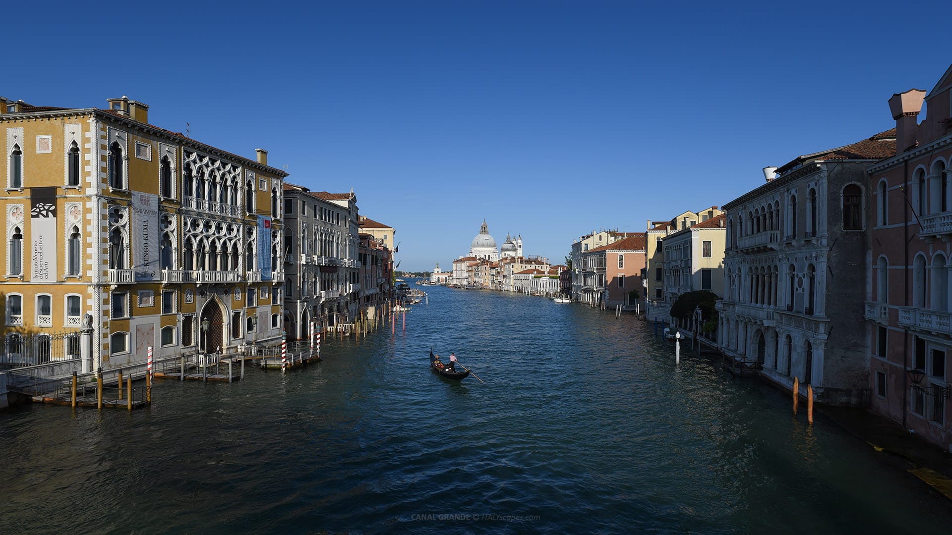
View of the Grand Canal from Ponte dell’Accademia
Architecture on the Grand Canal (Canal Grande)
A Continuous Architectural Museum
The Grand Canal is bordered by a remarkable sequence of palaces, churches, and historic buildings. More than 170 buildings face the canal, many dating from the 13th to the 18th centuries, when Venice was one of Europe’s great maritime and artistic powers.
The architecture of the Grand Canal is unusual because its main façades face the water. In most cities, the principal entrance opens onto a street or square. In Venice, the prestigious entrance was often the water gate, reached directly by boat.
Many palaces followed a practical Venetian layout. The ground floor was used for storage, service areas, or commercial functions, while the upper floors contained the main halls and private rooms. The central hall often opened toward the canal through large windows.
Venetian-Byzantine Architecture
The earliest important palaces on the Grand Canal preserve traces of Venetian-Byzantine architecture, a style shaped by Venice’s links with Constantinople and the eastern Mediterranean. These buildings often combine round arches, decorative surfaces, and a taste for precious materials.
Examples associated with this early phase include Ca’ Farsetti, Ca’ Loredan, and Ca’ da Mosto. Their forms reflect a period when Venice was absorbing artistic influences from Byzantium while developing its own lagoon architecture and civic identity.
These palaces were not massive defensive residences like mainland castles. They were urban houses for families involved in government, trade, and diplomacy. Their beauty came from rhythm, proportion, marble decoration, and the relationship between façade and water.
Venetian Gothic Palaces
From the 14th century onward, Venetian Gothic became one of the defining styles of the Grand Canal. It adapted Gothic forms to lagoon conditions, creating façades with pointed arches, slender columns, quatrefoils, balconies, and light, lace-like stone decoration.
Among the most important Gothic buildings on the canal are Ca’ Foscari, Palazzo Pisani Moretta, Palazzo Barbaro, Palazzo Loredan dell’Ambasciatore, and Palazzo Cavalli-Franchetti. These structures show how aristocratic families used architecture to display status.
Venetian Gothic differed from northern Gothic cathedrals. Instead of emphasizing height and heavy verticality, it created elegant façades suited to reflection, light, and water. Large windows opened the main halls toward the canal, while decorative stonework enriched the surface.
Ca’ Foscari is especially important because of its scale and position. Built for Doge Francesco Foscari, it became one of the most imposing palaces on the Grand Canal. Today, it is associated with the university that carries the Foscari name.
Renaissance Palaces
By the late 15th century, Renaissance architecture began to reshape the Grand Canal. New façades emphasized symmetry, classical orders, rounded arches, clear proportions, and more regular surfaces. Venice adopted Renaissance language while maintaining the canal-facing palace tradition.
Important Renaissance buildings include Ca’ Dario, Palazzo Corner Spinelli, and Ca’ Vendramin Calergi. These palaces reflect a cultural shift toward classical forms, but they remained unmistakably Venetian because they were designed for water access and public visibility.
In the 16th century, architects such as Jacopo Sansovino helped transform Venetian architecture. Works connected with this period include Palazzo Corner della Ca’ Granda and Palazzo Dolfin Manin, both reflecting the grandeur of Renaissance palace design.
Other Renaissance buildings facing the canal include Palazzo Grimani di San Luca and Palazzo Papadopoli. Their façades show stronger classical organization, with columns, orders, and horizontal divisions that contrast with the more decorative rhythm of Venetian Gothic.
Baroque Grandeur
The Baroque period gave the Grand Canal some of its most theatrical monuments. This style emphasized movement, scale, dramatic effects, rich surfaces, and powerful urban presence. In Venice, Baroque architecture often used the water as part of its visual stage.
The most famous Baroque monument on the Grand Canal is the Basilica of Santa Maria della Salute. Designed by Baldassare Longhena, it stands near the entrance to the Saint Mark’s Basin and is one of the most recognizable silhouettes in Venice.
Longhena also designed important palaces such as Ca’ Pesaro and Ca’ Rezzonico. Both buildings show the monumental confidence of Venetian Baroque architecture, with strong façades, large windows, sculptural decoration, and a sense of aristocratic power.
Late Baroque and Neoclassical Transformations
The Grand Canal continued to change during the 18th century. Some projects completed earlier Baroque ideas, while others moved toward Neoclassical restraint. Venice was no longer expanding as aggressively as in earlier centuries, but its architectural culture remained sophisticated.
The Church of Santa Maria di Nazareth, also known as the Scalzi Church, stands near the railway station area. Its richly decorated façade and interior belong to the Baroque world and contribute to the architectural sequence near the northern end of the canal.
Neoclassical taste later brought more controlled forms. Buildings such as Palazzo Grassi and the Church of San Simeone Piccolo reflect the classical revival, with columns, pediments, domes, and more disciplined geometry than the animated Baroque façades.

Palazzo Grassi overlooking the Grand Canal
The Bridges on the Grand Canal (Canal Grande)
Why There Are Only Four Bridges
Although the Grand Canal divides Venice, only four bridges cross it. This may seem surprising, but for most of Venetian history, boats were the natural way to move across water. Bridges were expensive, technically difficult, and sometimes unnecessary in a boat-based city.
The four bridges are Rialto Bridge, Ponte dell’Accademia, Ponte degli Scalzi, and Ponte della Costituzione. They belong to different periods and serve different urban needs, from medieval commerce to railway access, museum connections, and modern pedestrian circulation.
Visitors can also cross the canal by traghetto, the traditional gondola ferry service operating at selected points. These short crossings continue an older habit of movement, when everyday Venetians crossed the Grand Canal by boat rather than walking to a bridge.
Rialto Bridge
The Rialto Bridge is the oldest and most famous bridge over the Grand Canal. The first crossing at Rialto dates to the 12th century, when a pontoon bridge was created to connect the market area with the political and commercial heart of Venice.
The current stone bridge was built between 1588 and 1591, replacing earlier wooden structures. It was designed by Antonio da Ponte and remains one of the most recognizable monuments in Venice, with a single stone arch spanning the canal.
Rialto Bridge links the districts of San Marco and San Polo. Its location is not accidental. It stands near the historic Rialto market, an area that was central to Venetian commerce, finance, and daily life for centuries.
Ponte dell’Accademia
The Ponte dell’Accademia crosses the Grand Canal near its southern end, linking Dorsoduro with San Marco. It takes its name from the nearby Accademia area, historically connected with the Academy of Fine Arts and the Gallerie dell’Accademia.
The first bridge here was a metal structure opened in the 19th century. In 1933, it was replaced by a wooden bridge designed by Eugenio Miozzi. Although intended as a practical solution, the wooden structure became one of Venice’s beloved crossings.
The Accademia Bridge is famous for its views. From its highest point, visitors can see the Grand Canal curving toward Santa Maria della Salute and the Saint Mark’s Basin. This is one of the most photographed perspectives in the city.
Ponte degli Scalzi
The Ponte degli Scalzi stands close to Santa Lucia railway station, making it one of the first Grand Canal bridges encountered by many visitors. It connects the station side with the area near the Church of Santa Maria di Nazareth, known as the Scalzi.
The present bridge was designed by Eugenio Miozzi and completed in 1934. It replaced an earlier iron bridge from the 19th century. Built as a stone arch, it was created to fit more harmoniously into the Venetian urban setting.
Its position is practical and symbolic. The railway brought a new form of arrival to Venice, and the bridge helped integrate the station area into the pedestrian fabric of the historic city. It remains one of the busiest crossings near the northern canal entrance.
Ponte della Costituzione
The Ponte della Costituzione is the newest bridge over the Grand Canal. Designed by Santiago Calatrava, it connects Piazzale Roma with the Santa Lucia railway station area, improving pedestrian movement between Venice’s road terminal and rail terminal.
The bridge was inaugurated in 2008. Its contemporary design, using glass, steel, and stone, contrasts sharply with the older bridges of the canal. Because of this, it has often been discussed as one of Venice’s most controversial modern additions.
Its location is important. Piazzale Roma is one of the few places in Venice accessible by cars and buses. The bridge therefore serves a major practical function, helping people move between land transport, the railway station, and the historic pedestrian city.
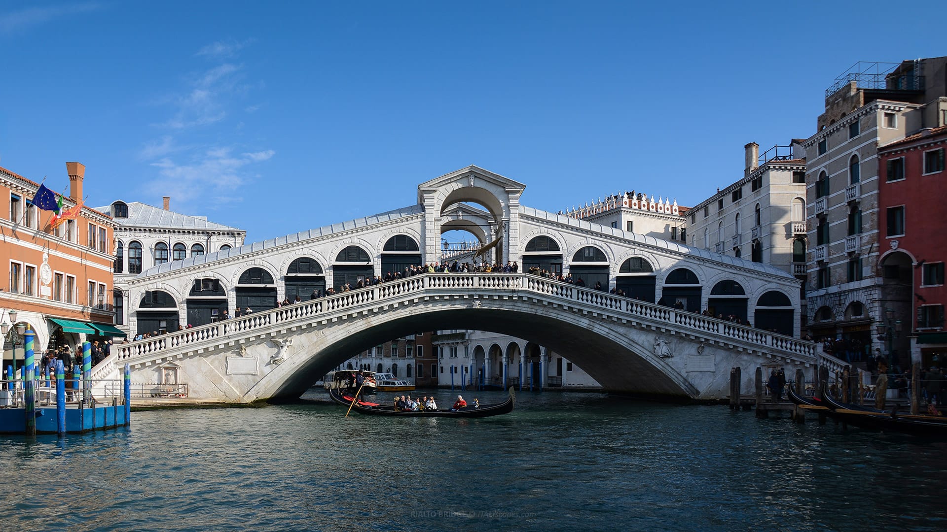
Rialto Bridge (Ponte di Rialto)
How to Experience the Grand Canal (Canal Grande)
By Vaporetto
One of the easiest ways to experience the Grand Canal is by taking vaporetto Line 1. This public waterbus route travels slowly along the canal, stopping at many important points and offering continuous views of palaces, churches, bridges, and everyday boat traffic.
From Piazzale Roma or Ferrovia, Line 1 follows the Grand Canal toward Rialto, Accademia, Santa Maria del Giglio, Salute, and San Marco Vallaresso. The ride offers a practical introduction to Venice’s geography and architecture.
The journey from Piazzale Roma to San Marco Vallaresso usually takes around 45 minutes, depending on service conditions and stops. It is slower than some routes, but that is exactly why it is valuable for visitors who want to observe the canal carefully.
By Gondola or Private Boat
A gondola ride offers a more intimate view of the Grand Canal and the smaller canals connected to it. Gondolas move lower on the water than vaporetti, making façades, entrances, steps, and reflections feel closer and more detailed.
Many gondola routes include short sections of the Grand Canal combined with quieter side canals. This gives a better sense of how Venice works as a network of waterways, where the broad canal connects to narrow residential passages and hidden corners.
Private water taxis provide another perspective. They are faster and more expensive, but they show how the Grand Canal still functions as a transport corridor. From the water, Venice appears less like a pedestrian city and more like a maritime capital.
On Foot from the Bridges
Walking across the four bridges gives a different experience of the Grand Canal. Each bridge offers a fixed viewpoint over a different section of the waterway. Rialto shows the commercial heart, while Accademia opens toward Salute and the basin.
Ponte degli Scalzi gives a strong first impression near the railway station. Ponte della Costituzione shows the modern arrival zone near Piazzale Roma. Together, the four bridges create a sequence from transport gateway to historic marketplace and monumental lagoon entrance.
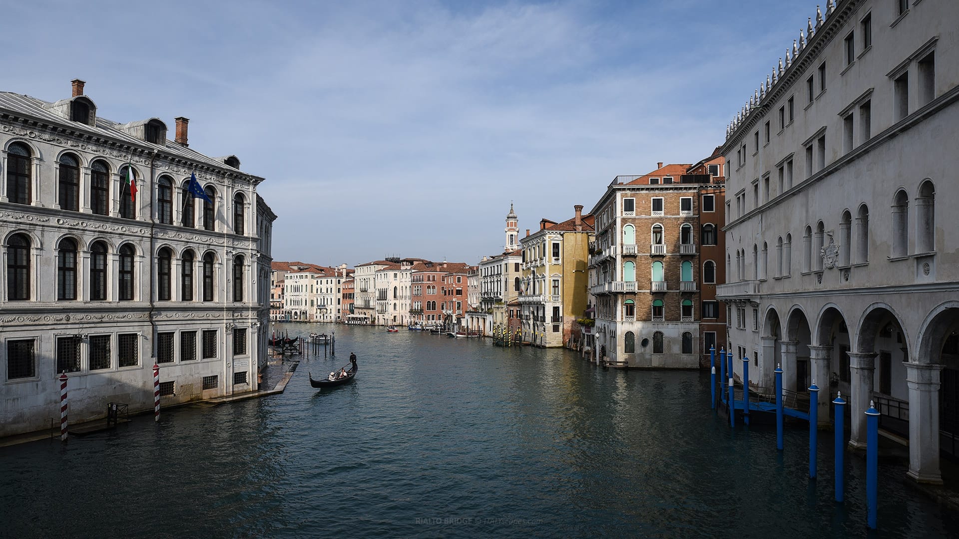
View of the Canal Grande from Ponte di Rialto
How to Get to the Grand Canal (Canal Grande)
From Piazzale Roma and Santa Lucia Station
The western end of the Grand Canal is located near Piazzale Roma, Venice’s main road terminal. This is one of the few places in the historic city where buses, cars, and taxis can arrive before visitors continue on foot or by boat.
Nearby stands Venezia Santa Lucia railway station, one of the most important entry points into Venice. From the station steps, visitors immediately see the Grand Canal, with boat stops, palaces, bridges, and constant movement on the water.
The closest vaporetto stops in this area include Piazzale Roma and Ferrovia. These stops are served by several public transport lines, including routes that travel along or connect with the Grand Canal and the wider lagoon network.
From Saint Mark’s Area
The other end of the Grand Canal is near the Saint Mark’s Basin, close to the monumental zone of Venice. The relevant vaporetto stop for the Grand Canal route is San Marco Vallaresso, served by Line 1.
From San Marco Vallaresso, visitors can travel back along the canal toward Salute, Accademia, Rialto, Ferrovia, and Piazzale Roma. This direction is especially useful after visiting Saint Mark’s Square, the Doge’s Palace, or the waterfront.
The area near the canal’s eastern end offers some of the most famous views in Venice. Here, the Grand Canal meets the open basin, with Santa Maria della Salute, Punta della Dogana, San Giorgio Maggiore, and the lagoon forming a monumental panorama.
Frequently Asked Questions about Grand Canal (Canal Grande)
What is the Grand Canal in Venice?
The Grand Canal, or Canal Grande, is the main waterway of Venice, crossing the historic center in an inverted S shape and functioning as the city’s most important aquatic route.
How long is the Grand Canal?
The Grand Canal is about 3.8 kilometers long. Its width varies between approximately 30 and 70 meters, while its average depth is around 5 meters, allowing regular boat traffic.
How many bridges cross the Canal Grande?
The Canal Grande is crossed by four bridges: Rialto Bridge, Ponte dell’Accademia, Ponte degli Scalzi, and Ponte della Costituzione, the newest bridge, designed by Santiago Calatrava.
What is the oldest bridge over the Grand Canal?
The Rialto Bridge is the oldest and most famous bridge over the Grand Canal. The current stone bridge was completed in the late 16th century, replacing earlier wooden crossings.
What is the best way to see the Canal Grande?
The best way to see the Canal Grande is by taking vaporetto Line 1, which slowly follows the waterway and offers clear views of palaces, bridges, churches, and daily boat traffic.
Sources: -
Photos
-
Map
-
Reviews


